**2014 UPDATE** Based on rider feedback, we will not be handing out maps and directions this year as very few people say they actually use them. The maps below can be printed out if you would like to take a map with you. Each individual route can also be viewed on Map My Ride – with the option to print the map or download a GPX file too.
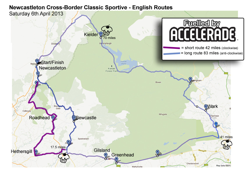
Saturday – Sportive Routes in England (approx. 42 & 83 miles)
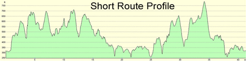
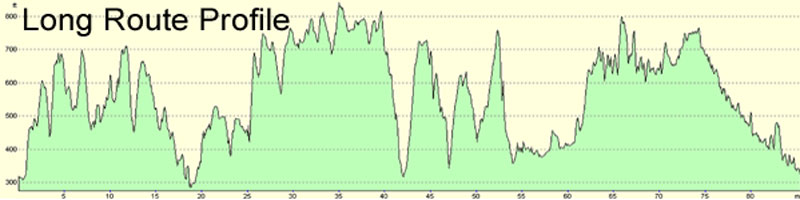
Click profiles to enlarge
View Routes on Map My Ride (GPX downloads available)
Download English route written directions (doc)
Both routes head south out of Newcastleton village centre and immediately start heading up into Kershope forest and wind gently through the quiet Cumbrian lanes through Bewcastle towards Askerton Castle. (Feed Station at 18 miles.) Just after the feed station the shorter route branches off to the west before heading back north to the village.
The longer route turns east towards Gilsland crossing over Hadrian’s Wall and joins the old Roman road, making the long, exposed drag east following the route of the wall. (Pray for a tail wind here or just get your head down and pedal!) At Tower Tye it turns north across the rolling Northumberland landscape towards Bellingham (Feed Station approx 40 miles) before setting out on the lonely road to Kielder Reservoir. Enjoy the glorious views and the stillness of Europe’s largest manmade forest as you follow the reservoir’s shoreline to it’s northern tip and Kielder village. (Feed Station approx 69 miles) From here there’s just a short climb to cross over the border and then it’s almost downhill all the way back to the village start.
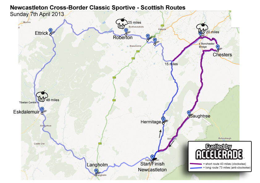
Sunday – Sportive Routes in Scotland (approx. 45 & 81 miles)
**IMPORTANT: ROUTE CHANGE DUE TO DIVERSION**
The routes head north and gradually climb up through Wauchope Forest on the quiet road to Hawick. Both routes then head off just before Hawick and head east towards Bonchester Bridge. (Feed Station 1 approx 18 miles.) The routes split here. The short route then starts the long, gradual climb up and over the forest again but the car park at the summit marks the start of a very long and very rewarding descent back to Newcastleton.
The long route continues to Hawick and heads west on the B711, climbing up to Alemoor Reservoir. (Feed Station approx 25 miles) Elevation remains high as it skirts Craik Forest following a variety of small Burns. At Ettrick the route turns south and climbs high into the forest before starting what feels like a never ending descent down through Eskdalemuir – this truly is a road cyclists dream road!) (Feed Station approx 56 miles) near the Tibetan Centre, and on into Langholm. Now comes the sting in the tail with the final climb over Terrona Hill back to Newcastleton.
View Long route on Map My Ride (GPX download available)
Short route will be available on Friday.
Enter 2014 Event Online Now

A 4 mile road hill climb TT with 800ft of ascent from the centre of Newcasleton.
- From 5.30pm, Friday 4th April 2014
- Two categories: 12-16 yrs and 17yrs+
- £50 cash prize for fastest 17yrs+
- Top 3 prizes for 12-16yrs
- Pre-entry £3 (on the day £4)
- Full details coming soon…
Enter now using the Sportive Entry form

The sportives are being organised in association with Visit Newcastleton. Please visit the website to book accommodation and for more information about the area.

Free Accelerade Download
Download a free copy of the Accelerade Performance Nutrition Handbook(1.2MB
The 23-page pdf handbook features performance articles and tips from nutrition professionals, product details, a nutrition action plan and more.